Sur La Plaque!

Bicycles, beer and other self-indulgent ruminations.

Seventeen: Cloudbound (Falls of Rough to Sebree)

Miles: 76
Total:1,169

Your first clue that Bob Hardison’s a stand-up dude is in his driveway. He drives a late ’90s Toyota Avalon. My man. But we’ll get back to Bob in a few grafs.

I was up and on the road by 6:15 a.m. (In Central Time for the foreseeable future). I said goodbye to BJ — Louis and Matt were sawing logs. They’re headed to Owensboro tonight — off the reservation, but it’s a big city where they can get plenty of World-Cup action. Right now, they’re riding bikes between matches. Pretty cool.

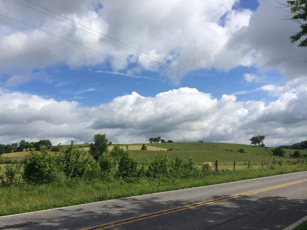
Falls of Rough was foggy this morning. An ephemeral blanket cloaking everything in damp and low visibility. Traffic was light, luckily. Out of town I caught the tail end of a chase. A pair of hounds went round and round with a rabbit until they went round and round no more. The rabbit lost this one.

The fog burned off by Fordsville, where a driver shouted, “Hey, you wouldn’t happen to have a quart of motor oil, would you?” I replied nope … At which point I realized he was talking to a fellow across the street. We (I) laughed harder than we (I) should have.

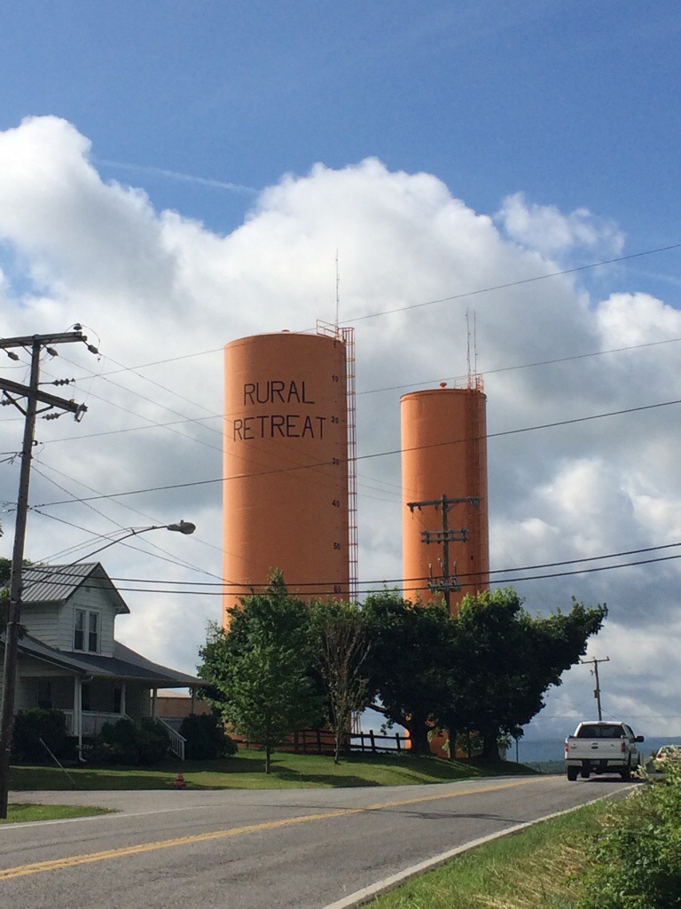
I took a break for lunch in Utica, at a Marathon gas station. The ACA maps use a liberal definition when it comes to identifying grocery stores and restaurants. I continue to miss produce in small towns. Many homes have gardens, but if you’re not farming, you’re either living out of the freezer section or driving quite a few miles for vegetables.

In Beech Grove I came across a historical marker for James Gresham, born in town and the first American killed in WWI on November 3, 1917. A dubious distinction.

Home tonight is First Baptist in Sebree, a town of about 1,500. I rode up and met Bob Hardison, who turned out to be the pastor. He and his wife, Violet, have been at the church and hosting cyclists since 1979. The church put me up in its youth center, complete with a hot shower, mattress, A/C, wifi, washer/dryer and a full kitchen, which I didn’t have the opportunity to use as Bob and Violet invited me to dinner in their home, next door. Violet likes to feed “her cyclists” when she can, and cooked for 26 Ride the US for MS cyclists a few days ago (!). She fixed chicken, stir-fried vegetables with noodles, corn and finished it off with a big dish of ice cream topped with strawberries.

Right about 8 p.m., as we were cleaning up, Trevor rolled in. Violet fired the kitchen back up, I chopped squash and broccoli (yeah, veggies!) and we had dinner again. Trevor’s riding from Baltimore to Moab, Utah, where he’ll learn to build energy-efficient homes from the ground up. He’s loaded bike packing style, and covering serious ground (106 miles today). Violet is one of 15 children born into cotton-sharecropper family with an alcoholic and abusive father. Both she and Bob (married 45 years) are dedicated to family (two sons, six grandchildren), ministry and each other. Hearing stories of their lives and those of cyclists passing though was both entertaining and moving.

She baked cookies, too. She says that’s how you know she really likes you.

Sixteen: Turkeys Can Fly (Mammoth Cave National Park to Falls of Rough)

Miles: 86
Total:1,093

Time is an interesting concept. I woke up in Central Time, had lunch in Eastern Time, and went to sleep in Central Time. Nuts. This temporal border’s existence probably explains why the park’s visitor center says “Central Time” over the doorway and why a disembodied voice announces multiple reminders for tours.

This morning I descended to the Green River, where a ferry took me across, but left me to climb the other embankment on my own. The nice thing about ferries is that you know when a car’s coming from behind, based on its frequency — there’s no other automobile access point. I flushed a turkey out of a ditch on a climb. These guys fly like I dance. It’s all elbows and no one’s having a good time. Eventually the song changes and you creep away for some punch, or something.

I rejoined the main route in Sonora, which sounds awfully utopian/like the name of a midsize sedan for a town of 513 souls. Coming out of the Dollar General, a silver Cavalier pulls up and asks me The Usual. He (being Larry), recommends I stop at a store that’s not really a store … But I’ll supposedly see a lot of cars parked along a side street and there’s a faded sign that says Brook’s Grocery. Go in, says Larry, they have a book dating from 1976 with cyclists coming through. Oh, and you can get a real meal there. I hope Larry’s on Brook’s payroll, because I notice lots of entries in the book that start with, “thanks to Larry for recommending … ”

But it was worth a stop. I page through the book, which was started by the now-owner’s mother, and there are entries dating to the inaugural Bikecentennial. Lunch wasn’t bad, either.

Fortified, and somehow back in EST, I push on and meet two eastbound cyclists. One started in San Diego and took the Western Express, the other’s from San Francisco, but started in Pueblo, Colorado, and is finishing part two this summer.

The wind really picked up this afternoon. Mostly a cross-current, almost as annoying as a headwind. The wind tends to be most vigorous during the heat of the day. Another reason to start early. Both eastbounders said they had headwinds in Kansas. Maybe I’ll luck out.

The afternoon heat snapped with a quick 15-minute downpour. I was about to turn left on SR 79 when I found shelter under a liquor store overhang. I’m not a religious person, but I took that as a sign and picked up a sixer of Sweetwater IPA, a beer not distributed in my neck of the woods. Divine intervention continued, when I reconnected with BJ, Matt and Louis at Falls of Rough campground, my home for the night. I spent the day with them in Afton, and they had some stories to tell. Matt popped a spoke, so they ended up hitching a couple of times to a bike shop, then renting a U-Haul to get them and their bikes back on schedule. We share the campsite and the beer. Everybody wins. The state resort park (everything’s classier in KY) has an attached lodge where you can sleep in comfort. Said lodge has a buffet, which we ran a train on. Frog legs really do taste like chicken. Like delicious, deep-fried chicken.


Fifteen: “How Black Black Can Be” (Hodgenville to Mammoth Cave National Park)

Miles: 51
Total: 1,007

I took a side trip today. The TransAm, at 4,200 miles long, takes a lackadaisical track across the U.S., but even it offers Mammoth Cave up as an optional extra, tacking on 85 miles.

I got an early start to beat the heat, arriving in the park around noon (I also slipped into Central Time at the Hardin/Hart county line and gained an hour). In Munfordville I stopped to see Kentucky Stonehenge — exactly what it sounds like.

A dozen wild turkeys greeted me in the national park — all wildlife is federally protected, even snakes and spiders. I couldn’t get close enough for a decent picture without them running off into the woods.

There’s no entrance fee, but camping is $17, and you’ve got to tack on another $3 for a 10-minute shower. Come on! Pleasant campground, but the lack of walk-in sites meant lots of RVs. Interestingly, the bicycle’s the preferred means of transport (kids and adults) within the campground.

I took the 2 p.m. “Domes and Dripstones” tour, led by Rangers John and Steve, retired high school teachers. The two-hour tour covers 3/4 of a mile and 500 tight, twisting steps. Most of Mammoth’s more than 400 miles of surveyed passageway (more than twice as long as the next-nearest competitor, and geologists think perhaps 600 miles await discovery) are ancient dry riverbed, but a part of our tour took us to a wet area of the cave, where drips and seeps have created remarkable formations.

We entered though apparent doorway to nowhere (Dharma-initiative style) and descended 250′. The cave’s a cool 50 degrees F, and coming out the other end into the 90 degree heat and rampant humidity was like slamming into a brick wall. The respite was easily worth $12 all on its own. Native people explored the cave about 20,000 years ago through 4,000 years ago and researchers have found leavings (torches, shells, the occasional human remains) more than 10 miles in. There’s no evidence of exploration between about 4,000 years ago and 1798 when the cave was rediscovered by a hunter tracking a wounded bear.

The U.S. looked for status symbols in the 1800s — the country was an industrial and military power, but didn’t have ancient cities or the depth of culture Europe offered. In addition to Mammoth, the Grand Canyon and the giant redwoods helped bolster America’s reputation of scenic wonder.

In addition to its to not-insignificant tourist value, the cave produced a heck of a lot of saltpeter for the War of 1812. Congress authorized it as a national park in 1926 and it was established in 1941. Geologists and biologists are surveying the caves, studying how water moves through the area. An evening presentation by Ranger Jackie Wheet on the curiosity of caves related this anecdote:

Researchers frequently use dye tracing to track water movement. They’ll inject vividly colored (but harmless) dye in the surrounding area, and then wait to see where it shows up underground. They asked a nearby landowner for permission to trace his well. He wasn’t comfortable with the idea, and when the scientists pushed, he said, you can flush it down my toilet. Let’s see where my septic system leads. After all, he didn’t want to cause downstream problems. Well, a couple of days later the park gets a call from the guy, totally peeveed. He’s showering with green water. He thought they’d dumped dye in his well against his wishes, but his septic field and well draw were closer than expected.

Home tonight is the aforementioned campground. Site 81. While I was out, an enterprising squirrel helped himself to 14 cents’ of fig bars. I also rolled over 1,000 miles on the TransAm.


Fourteen: Angel’s Share (Lincoln Homestead Park to Hodgenville)

Miles: 72
Total: 956

Right over the Nelson County line I witnessed something that filled me with deep, visceral sadness. Promise lost. Opportunity wasted. Unrealized potential, posed parallel the solid yellow line. A king-size Reese’s cup package, crushed. Its insides, outside. Time of death: unknown. Time of discovery: quarter to eight. Its cups arrayed like a traffic light, peanut butter oozing out the rays of a grade-school sun.

Luckily, much happier things waited in Nelson County’s Bardstown. I picked up a sandwich for later and rolled past Heaven Hill’s collection of bonded barrelhouses. They must have at least a dozen within view of the road, and product seemed to be moving steadily on HH-branded semis.

My destination, a little up the road. Willet Distillery’s right on SR 49, up the hill. I missed the 10 a.m. tour by a few minutes, but had my lunch in the shade and waited till 11 a.m. when Donna gave me a one-on-one tour (low demand on a Wednesday morning, I guess.). Founded in 1936, and still family owned, Willet makes much less by volume than the big guys in the area, and bills itself a craft distillery. They’ve got two mash cookers, one that holds 3,000 lbs of grain, the other 6,000 lbs. Sounds big to me. Fermentation happens in open-topped 10,000 gallon vats, and lasts four or five days, depending on ambient temperature. Willet’s got a column still for its beer-stripping runs and an ancient copper pot still for final distillations.

Outside the distillery we ventured into the barreling room, where white spirits are cut to cask strength and rolled out into aging warehouses to sit for the next four years or so. Simply tin wrapped around a wooden skeleton, each five-level barrelhouse holds 6,000 53-gallon casks. There’re plumb bobs hung from the ceiling to ensure stability through even loading. The barrelhouses exude the smell of whiskey, and walking inside’s overpowering, in a Very Good Way.

Donna tells me all the corn comes from Nelson County, which helps explain why I’ve been seeing so much of it the past few days. A lot of corn and horses west of Berea. Surprisingly, not a ton of tobacco, and the plants I have seen are very small. We try a pair of samples, including a remarkably citrusy two-year old rye.

I’m back on the road in the heat of the day, headed to President Lincoln’s birthplace in LaRue County. It’s a national historic site, and I enjoy a 15-minute film in an ice-cold theater before climbing 56 steps (one for each year of his life) up the monument and paying a visit to what was once thought to be Lincoln’s birth cabin. It’s known now to be much too recent, dating from the 1840s, but neat to visit regardless. The Lincolns, including Abraham, spend two years at Sinking Spring before a land-ownership dispute pushes them a few miles away.

Sinking Spring’s just a short ride from tonight’s home, Hodgenville’s LaRue County Park. I stop at Dollar General for supplies, and we have a new champion in our kcal/dollar race: 21 oz. of generic fig bars for a buck. 2200 Calories. It might be tough to unseat this King Fig.

There’s a pavilion toward the back I have my eye on, but when I ask the folks at the pool about a shower, they say sure, we’ve got a cold one here, but if you’d rather, there’s a hot shower in our community building, just across the field. Needless to say, I rathered and set up inside the somewhat air-conditioned building. Heaven. Thank you, LaRue County.


Thirteen: “I Think You Missed Your Turn” (Berea to Lincoln Homestead Park)

Miles: 78
Total: 884

You know, that neither-nor kind of light, the light that’s not really, the light that interchangeably means incipient dawn or incipient darkness.

That kind of light that means you’re getting a wicked early start, that or you slept through the entire day and are up just in time for a fresh goodnight.

I was out of the tent about 5:30 a.m., ready to get down the road while it’s cool. The more miles in before a midday break, the happier I am. Today, it turned out to be about 50 miles before I pulled off in Harrodsburg for lunch and to use the library.

I love libraries. Entirely possible I’m biased by the A/C, but every experience has been great. Friendly staff — the librarian in Berea had (and I assume still possesses) a British accent, which really classed up the joint — and a chance to contact home (you can only do so much computing on an iPhone, especially away from major cities and fat data coverage.) Damascus, Virginia, has a gorgeous facility that caters to AT hikers and bicycle tourists. They even have a register to share who you are, and where you’re from.

ANYWAY. Bicycle route signs disappeared a few days ago, but this wasn’t an issue because all the intersections were labeled. Not the case today, where I had three unlabeled streets within 15 miles of Berea. I missed an anonymous right to stay on SR 595 and ended up in Paint Lick (what a name, eh?) where my unfolded map flagged Steve down. He lives in town, does a little touring and hopes to have a B&B&B open in a couple years (bed, breakfast, brewpub) and asked what would draw cyclists. I told him a beer and place to put a tent up would do it for me. He said Garrard County’s wet (and made a little sign of the cross), and that there’s a park where you could camp, except there’s a tent revival currently in progress (yeah!). I backtracked about two miles, made my turn and then carefully watched my map and odometer for a right onto the unmarked and aptly-named Ninja Bridge Road. Nailed it. A little later, on Jess Ray road, a pickup passed me and the driver said, “I think you missed your turn” with the dignified amusement you save for Lycra-clad weirdos who pass through town every summer. Sure enough, back about 100 yards was my unmarked intersection. Some Good Samaritan cyclist had attached a safety triangle to a telephone pole. Thank you, kind people of Kentucky.

As the sun rose higher, the wind picked up. Without all those huge hills (the little peaks in Western Kentucky are called knobs, as some Berea-folk informed me) around to stop gusts, you trade one demon for another. A fresh hell. Variety is the spice of life. It wasn’t too bad, actually, except for the stiff crosswinds that occasionally pushed me sideways. I tacked accordingly to avoid grazing passenger compartments.

In addition to a fab library, Harrodsburg is home to Fort Harrod, Kentucky’s first permanent settlement (built by James Harrod in 1774) and probably just as important as Boone’s Wilderness road in westward expansion. Near the fort is the chapel where President Lincoln’s parents married and a gargantuan Osage orange tree, dating from the late 18th century, 88′ tall, 76′ around and the unofficial national champion (split trunk).

More pastoral landscape through Rose Hill — pleasant riding and views with a fair number of ups and downs.

Cruising in to the home stretch, I stopped for a photo of a farm sign advertising BueLingo, a double-stuff Oreo cookie of beef. The owner came out and we talked for a little bit. He told me that while he’d never been to Pittsburgh, Kentucky had it all. In fact, he bet a Texas army buddy that Kentucky has more lakes than the longhorn state. You’ll have to do your own fact checking on that one.

I’m stopped tonight Lincoln Homestead Park’s picnic pavilion, where I’m resisting my tent despite a highly motivated mosquito population. Cyclists can camp overnight for free. There’s no shower, but I’ve got running water, flush toilets and electricity. Just down the road from the pavilion is the park proper. It’s home to the cabin Nancy Lincoln (née Hanks) called home while Thomas Lincoln courted her. In addition, there’s a replica of the cabin Thomas grew up in while raised by his mother, Bathsheba, after Abraham Sr.’s death. I’m too late for a tour, but a sign says some of the furniture was made by Thomas Lincoln. An accomplished woodworker and important father, he wasn’t a great farmer. Next to the cabins is an 18-hole golf course, and part of the park. Nothing like teeing off that par five just a few dozen yards from history.


Twelve: Two Outta Three Ain’t Bad (Berea to Berea)

Miles: 5

Total: 811

Today was the my first day off since leaving Yorktown, and it felt nice to ride around town on an unloaded bicycle, no longer a dowsing rod for grades. Oh! Kentucky charges $15 for two nights’ camping, and the cashier offered the wifi password on the back of a Marlboro carton. After breakfast, I rode into town for a cup of fantastic coffee at Berea Coffee and Tea, where I planned Map 10’s overnight stops. It’s looking like I’ll be Murphysboro, Illinois, Monday, June 23. Berea College is a liberal arts work college, founded by John Fee in 1885, and special in that (a) it charges no tuition — you pay your way through work-study programs, (b) it was the first coeducational and racially integrated southern college (a colossal accomplishment considering the time and location), (c) that you’re basically ineligible for admission if your parents make more $90,000. I took a 45-minute walking tour with Andy, a current student, who really showed me around. He’s studying English and Music, and grew up in town. While it’s not common for students to live that close, the college gives hearty preference to Appalachia residents, so if you’re not from the mountains, it’s 50:50 you’re from another part of the country/another part of the world. With just 1,600 undergraduates, and no graduate programs, it’s a small school, but I’m really glad Andy took the time to show me around.

On his recommendation, I found Main Street Cafe for lunch, which was a mammoth Greek salad, followed by a burger and fries. I’d worked up a powerful craving for crunchy green stuff, and the salad satisfied. After lunch, I picked up strawberries, bananas, apples and grapes at the grocery store and visited the library to spend some time on this site and take care of other electronic odds and ends. I spent the rest of the afternoon consuming fruit, getting deeper into Infinite Jest, and working on my bike a little bit. I’m having trouble coaxing the front derailleur into serving up my big ring. An intermittent issue that needs more attention. I’d hoped to find a beer in Berea, but Madison County’s dry. Apparently you’ve got to head to Richmond County, about 10 miles away for a suds run. Sigh. Well, with coffee and fruit secured, today’s far from a failure. An early start tomorrow to Lincoln Homestead Park, just west of Maud. Should be an easy haul on fresh legs.


Eleven: Hantavirus Hangover (Buckhorn to Berea)

Miles: 70

Total: 806

I really slept in this morning and wasn’t on the road till just after 11 a.m., right as the sun was ramped to full strength. A mistake, but I was shot after a long day to Buckhorn and the lingering effects of Lookout’s hantavirus. Walter must’ve been off early, because I didn’t cross paths with him all day. We’ll have to swap contact info next time we meet up.

Lunch was in Booneville, named in honor of Daniel Boone, and seat of Owsley County. I resupplied at a Dollar General (that and Family Dollar are all over the place — the distinction escapes me) and took the cashier’s recommendation for Spencer’s Dairy Bar, just up the road. Not much is open on Sunday in a town of 81. There are tons of dairy bars and roadside ice cream stands — great fuel for a road-weary cyclist!

Near McKee I had to dismount my bike for the first time to deal with dogs. Two black labs and a few smaller terriers who were more curious than territorial, but still annoying. I don’t understand how people can (a) have that many dogs and (b) fail to train them. The homeowner had to yell for a couple of minutes before all but one retreated. The second lab kept me company for the better part of a mile down the road. I’m looking forward to Western Kentucky, reputed to have fewer dogs and gentler hills.

More elevation rounded out the day, including an impressive three-tier climb to Big Hill, not creatively named, but definitely an example of truth in advertising, where a welcome two-mile, 6-percent descent ushered me into Berea.

Home tonight is Oh! Kentucky Campground and RV park, which seems A-Oh!-K. I got in after the office closed, so I’ll settle up tomorrow. I’m taking tomorrow (Monday) off to see Berea, a college town of about 15,000, and give my legs a break before starting Map 10, which will take me 405 miles to Murphysboro, Illinois.


Ten: Let Sleeping Dogs Lie (Lookout to Buckhorn)

Miles: 97

Total: 736

Herbert Dean Hall for Knott Country Judge Executive. Vote Hall for All Knott County.

If I learned one thing thing today, it’s that Eastern Kentucky’s due for an election. That, and vote Hall. It was an early start after a crummy night’s sleep. As nice as Freeda Harris is, there’s lots of mouse activity, and I woke up with a headache and plenty of mucus. Last night, we pored over our maps for lodging options, and came up with just two: ride 50 miles to Hindman, where there’s a hostel, or push to Buckhorn, and an Army Corp of Engineers campground, about 95 miles away. Walter and I decided to make for Buckhorn, and the rest of the group was going to call it in Hindman. Walter’s got a ticket back to the Netherlands August 19, so he’s making miles early to give himself some cushion later on.

We left Lookout in the cool morning, around 7:30 a.m.,. Almost early enough to avoid detection by dogs. A lot of barking and pacing, but only a couple of chases. I found one dog lying in the middle of the road. I figured maybe roadkill, but his ears perked up as I rolled by. Thankfully, that’s all that rose. Gas’s $3.86 in Kentucky, FYI. We climbed up a few bigger hills today, where I’d work up a lather, then put on a jacket for the chilling descent. And I was reunited with old friend, SR 80, for a couple dozen miles. The shoulder’s wide, but there’s a thick rumble strip almost immediately to the right of the stripe, then a few feet of gravel, glass and grit, before either a steep dropoff or guardrail. It’s tough to find a spot where you (a) won’t be in traffic, (b) won’t have your fillings shaken loose or (c) put a piece of wire in your tire. I much prefer the quiet country roads.

Last-Chance Liquors greeted me at the top of the climb dividing Pike and Floyd counties. There are a lot of dry counties in Kentucky, but people must not be willing to trek up to the top of a mountain for a bottle, because the only customer in view was a yappy dog. I made it to Hindman around 2 p.m., which was bustling — folks out Saturday shopping. I stopped for some groceries (fresh produce is scary difficult to find along the way) at a Save-a-Lot and left my fluorescent vest on my rear rack, where it blew away. Luckily, a woman flagged me over down the road and returned it. Thank you, Toyota Tundra guardian angel. Bad habits. Hindman wouldn’t be a bad place to spend the night. It’s got a Dairy Queen.

Today’s my tenth night on the road. It’s also the first time I’ve had to shell out a non-voluntary donation for lodging. I was happy to pay it, because I had my first dinner invitation of the trip — Melissa and Faye are pedaling cross country West to East. They left San Diego March 29 (!) via the Western Express, and expect to be in Yorktown the first week in July. Their husbands, John and Kevin, are driving support in two RVs with four dogs. They’re on racing bikes with very little gear and a guaranteed soft bed each night. That’s the way to travel! We swapped stories about what’s ahead, and then tucked into an apple pie John’d picked up. Just what you want after a long day in the saddle. Great people!


Nine: The Breaks (Rosedale to Lookout, KENTUCKY)

Miles: 64
Total: 639

You would have been a god among men this morning, had you known how to service a Braun drip-coffee machine. We had the incorrigible bastard laid out in the O.R., disassembled, cleaned, put back together — no dice. Walter, our Dutch aerospace engineer, was puzzled and/or indifferent. There’s a different vibe in the morning around five others — it’s probably good to keep me from losing all my manners.

I spent the vast majority of today on SR 80, a narrow two-lane ribbon of frequently serpentine pavement, and was glad to leave it behind shortly after crossing into KENTUCKY(!). Lots of coal and logging trucks up and down the mountains all day. Riffling Jake brakes and smell of asbestos kept me company through the turns. I stopped in Haysi, Virginia, population 498, for lunch at the Pizza Factory, which turned out only mediocre pie, but huge cups of ice water, for which I was thankful.

It took a series of three hill climbs to make it into Breaks Interstate Park, operated at the junction between Virginia and Kentucky. It’s billed as the Grand Canyon of the South (by Dickinson County, at least), and the the views made the cast-iron bitch of a mountain worth scaling. Just on the other side, I crossed into Kentucky’s Pike County. It took me 8.5 days to bag my first state, and it’s a good feeling. Already I see more evidence of coal mining, both in truck volume, and their roadside anthracite leavings. The ladies at Haysi’s library say the mines run seven days a week (it’s a huge business here, though fracking’s also on the rise), but that traffic’ll be lighter over the weekends, so I’m planning to cover more miles Saturday and Sunday to take advantage of calmer ground.

My overnight halt is Lookout’s Freeda Harris Baptist Center. We’re in the gym, and everyone except Tika, who had been hoofing the AT through Damascus, and’s just getting his bike legs, trickled in, even Petunia the poodle. This place’s great. Just like last night’s Methodist sanctuary, there’s a full kitchen, stocked pantry, a spot inside to sleep and just a whisper of cell service. But tonight, we also have use of hot showers (shared with a truly ancient arachnid), and an industrial ice machine. Walter and I talked a bit about making beer. He and a few engineer friends earned some money from an airline delay, and are building a brewhouse/fermentation cellar in a garage.

Eight: Dem Der Hollers (Wytheville to Rosedale)

Miles: 96
Total: 575

The eternal optimist, I applied sunscreen this cloudy morning, and it served as an effective talisman, because except for an a.m.-cloudburst, I stayed dry all day. Last night two local (pre)teen boys came by, and after the Conversation, I asked for favorite breakfast spots. One said McDonald’s — the other, Hardee’s, which left me with peanut butter and bananas this morning. Packing up, a Wytheville crew pulled up in pickups to clean up the park for Chautauqua Days — a festival in the park — starting next Saturday. Luckily, they let me clear out before power washing the stage.

I stopped in Rural Retreat for chocolate milk and a few groceries. I hoped to use the library, but it didn’t open till 11 a.m., so I moved on. I apologize for the poor posting lately — Wytheville’s library doesn’t have public computers and my photos/posts are getting backed up, especially on evenings where I have no data service.

I climbed around Mount Rogers toward Troutdale — Rogers is Virginia’s highest peak, clocking in at 5,729′, and while I wasn’t routed to the very top, it was a slow, shady and not unpleasant crawl up. The road is surrounded by National Forest, which warns away motor vehicles, bicycles and hang gliders (!?). At the top, you enter Grayson County, home of the New River’s headwaters. In addition, this area’s full of great fishing — and stocked with trout — which perhaps explains the piscine naming conventions.

Just outside of Konnarock, two small — but serious — dogs gave chase. The Shih Tzu gave up at the property line, but Chihuahua was more tenacious, following me perhaps 1/4 mile down US 58, denying her owner, who yelled, “Candi! No! Come here!” (While I didn’t see the tag, I assume a dog that little has an I in her name.) But, man, she was fleet.

ACA provides two roads to Damascus: you can stay on US 58, or dip down onto the Virginia Creeper, a 35-mile gravel trail that runs between Abington and Whitetop, built on old railroad bed.  I chose 11 miles on the Creeper for a break from traffic, the sun and a change of scenery. In certain spots, I was just a few miles from Tennessee. It’s downhill to Damascus, and I made good time, with 60 miles in by 2 p.m. lunch (pancakes and coffee at MoJoe’s). Damascus is a hoppin’ town of about 1,000 people. It’s at the intersection of the Appalachian Trail and TransAm, which ensures a steady stream of traffic. This is the last time I’ll intersect the AT — I’ve been close to it since Troutville, and crossed it close to a dozen times, but our paths diverge here. I would have been happy to call Damascus home for the night, but I wanted to get up and over Hayter’s Gap, a 1,500′ climb over about four miles, so after lunch and bumming around Damascus’ very nice library for a bit, I hit the road. Out of town was gorgeous farmland and, somehow, even a bit more decline. In Meadowview I stopped by a farm-to-table restaurant/store, where I talked to a few folks who work on the Virginia Creeper. They invited me to stay the night at their house — in fact, they live right on route (on my “uphill” side), and frequently see cyclists slogging up/zipping down Hayter’s. I thanked them, but wanted to make it to Elk Garden tonight, so headed off. Between Meadowview and Hayter’s I looked up and realized I was hemmed in by mountains. I spit my gum out, and started the four-mile climb, carving switchbacks within switchbacks. At the top, I put my rain jacket on before descending. You work up quite a sweat climbing four miles at 5 m.p.h., and the downhill’s chilly.

Home tonight is Elk Garden United Methodist Church. We have quite a crowd. There are six of us, including a couple who are towing a dog (9 pounds, sunny disposition, thanks for asking) across with them. This is a great place to be — sleep inside, stocked kitchen and cold outdoor shower. Pictures to come with a better connection.

20140613-135424-50064873.jpg

20140613-135424-50064583.jpg

20140613-135424-50064129.jpg

20140613-135425-50065211.jpg

20140613-135425-50065564.jpg